

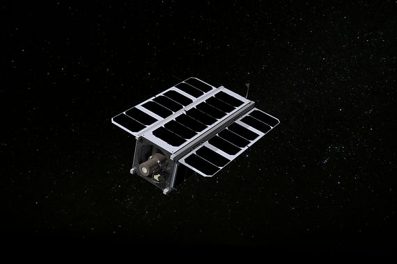
Astraeus-01
Fighting wildfires from space
Overview
Initiated in 2019, Astraeus-01 has long been GU Orbit's satellite mission, with periodic departures to focus on the competition with OirthirSAT and the CoudView mission. Astraeus-01 was first conceived as only a platform for students to test their satellite design and building capabilities, but, in February 2024, Astraeus-01's ambitions rose to that of fighting wildfires from space when it finally received a formal mission: to detect the risk and severity of wildfires in selected locations.
STATUS | In Development |
WEIGHT | TBD |
SIZE | 3U |
ORBIT | LEO |
CAMERA | NIR/G/B |
POWER | TBD |
FREQUENCY | 401-403 MHz (UHF)
2.025-2.11 GHz (S-Band) |
MODULATION | OOK (UHF)
QPSK (S-Band) |
Specifications

Aim
To do so, Astraeus-01 will be part of a risk and severity warning system for wildfires – a system that will send warning notifications if, in a selected area, a combination of the risk level of a wildfire starting and of the severity level of the possible impact/damage a wildfire could cause are above an acceptable level. Astraeus-01’s role in this system would be to regularly collect the vegetation and moisture indices – the type of vegetation and the amount of moisture – of selected areas using a combination of its Near Infrared camera and onboard processing in a novel application to the space environment and to Astraeus-01's small size. After 2 years of service, Astraeus-01 will test another novel feature, a drag sail designed by Matteo Ceriotti.
Astraeus-01's novelty
Typically, Earth observation satellites will down-link raw pictures of the places they’re observing to then be processed on Earth. This architecture means that the satellite has to send down huge data packets (the raw photos) which takes up a lot of time, resources and money. Astraeus-01's first novelty is in using its on-board processing to extract the vegetation and moisture indices despite Astraeus-01's small size and the environment of space. Further, this extracted data will then be transformed into an SVG map which will result in images 99% smaller than a typical raw image. All the necessary data can be extracted at the ground station with nothing valuable being lost.
Typical dragsails are usually just a flat plane, which creates aerodynamic instabilities whilst de-orbiting. Other previously flown dragsails have not been suitable for small CubeSat missions, therefore, Astraeus-01's second novelty is its dragsail and its deployment mechanism. Astraeus-01 will use a quasi-rhombic pyramid (QRP) design proposed by Ceriotti et al with a frontal effective area of 4m² and it will be deployed using nichrome burn wires. This low cost solution provides Astraeus-01 with greater stability when de-orbiting, whilst only being 0.57U and 0.4kg.
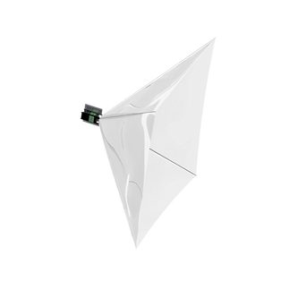
◀ Drag Sail 3D Model
The wider system
Apart from the novel aspects of Astraeus-01, the satellite will also consist of more standard satellite systems: magnetorquers, UHF and S-band transceivers, power systems, radiation protection, on-board computers and more!
The Astraeus-01 satellite will also be integrated into a ground system where the combined risk and severity factor is created. At the ground station, the downlinked vegetation and moisture indices map is then combined with other peripheral data from the area that was imaged – such as, the wind data, temperature data and the climate zone – to create the risk index. The risk index is then overlaid on a severity of impact map, creating the combined risk and severity index. The warning system monitors the risk and severity index, and upon the index surpassing an acceptable level, the appropriate authorities will be notified who can then take mitigation and preventative actions.